 We are working with two
fourth grade classrooms in Andover, Massachusetts. The objective is to expose the students to new places, cultures and experiences; tying questions and problems to their curriculum. We hope to create opportunities for creative writing, math, science and geography. We also meet with the classes several times per year to cover relevant topics and do workshops.
The log entries covering our travel and educational topics that we send to the classes every few weeks are archived below.
See Andover Townsman Newspaper Article for more information.
—————————————
Atlantic Project Ends:
The Atlantic Project part of our journey has come to an end. The students in the two fourth grade classes we worked with for two years have now moved on to middle school. Their enthusiasm and energy was wonderful, always full of questions and wanting to participate in classroom projects when we met with them. Along with learning about other countries, navigation and sailing, we hope they have learned to follow their dreams. Great success to all of you!
Frank and Holly, the fourth grade teachers, have also moved on. Holly has retired and Frank transferred to another elementary school in Andover. We appreciate their commitment to their students and to the Atlantic Project. Holly’s creativity has us still enjoying some of the hand-designed postcards and a book she helped the students produce describing parts of the adventure.
Lastly, thank you to Elizabeth Roos, the Principal of West Elementary School. It was Liz who put us together with Frank and Holly believing that this would be another opportunity for her students to learn and understand more about the world outside of Andover.
The project has been a dream of ours and we have thoroughly enjoyed writing the blogs, sending postcards, communicating with the teachers and especially meeting with the students for presentations and workshops.
As for where we go from here: We are currently in Greece and plan to travel throughout the Mediterranean for several more years before sailing back to the United States.
Signing off: Bob and Sara Knapp, s/v Quintessa

—————————————-
The Atlantic Project/Quintessa Log #34, 8/15/2015
Greece – Corinth Canal
Hi Crew,
We are now in Greece. Can you find the county of Greece on the world map? It is on the north side of the Mediterranean Sea between the countries of Italy and Turkey. The capital of Greece is Athens. It is the largest city in Greece. Greece has hundreds of islands.
People in Greece speak Greek. This is the first time we have gone to a country where the alphabet is not the same as ours. Their words look different. Some of their letters are the same. They have some that we do not have. We are learning those new letters and the sounds they make. We want to be able to speak to people we meet even if it is just a few words. The Greek word for “hello” is “yiasu”.
Greece is where the first marathon was run. In ancient times in the city of Marathon, Greece there was a battle. At the end of the battle, a man ran to the capital of Athens. He ran 24 miles to tell people in Athens that they had won the battle. The race was named for that city. The first marathon in the United States was held in Boston in 1897. How many years ago was that?

Going through Corinth Canal
After visiting some of the islands in the western area of Greece we crossed over to the center area. To get to this area we went through a canal called the Corinth Canal. Canals are channels dug through land areas. That allows boats and ships to go from one water body to another. Can you name other famous canals in the world? Canals are often used to shorten the distance boats need to travel. By taking the Corinth Canal we were able to save 150 miles from our trip. If we did not use the canal we would have had to go all the way around a big part of Greece, called a peninsula, to the other side.
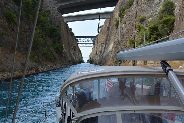
Looking back in Corinth Canal
The Corinth Canal was very exciting to go through. It is cut through rock. It is very narrow and deep. It is too narrow for very large boats. Most cruise ships do not fit in the canal. The Corinth canal was dug almost 200 years ago and is still used every day.
Signing off,
Bob and Sara Knapp
Latitude: 37° 55.3’ N
Longitude: 23° 01’ E
—————————————
The Atlantic Project/Quintessa Log #33, 7/17/2015
More Italy – Volcanos
Hi Crew,
We are now at a group of small islands just north of Sicily. They are called the Aeolian Islands. Can you locate these small islands on your map of the world?
Italy is famous for its volcanoes. Last month we reported on the volcano of Vesuvius in our blog to you. It is beside Pompeii. Since that was before you went on summer vacation you might want to re-read that blog (Blog #30).
There are volcanoes occur all over the world. Some countries have more than others. Volcanoes are especially common where one part of the earth’s crust is moving and rubbing against another part. Did you know that the land all over the earth is actually moving? It moves very slowly. In fact it moves so slowly that most people cannot tell it is moving.
In Italy there are a lot of volcanoes because this is an area where the land is moving a lot. This is the reason there are such fantastic mountains in Italy. When the crust of the earth moves it creates mountains and volcanoes. Volcanoes are formed when the movement causes a weakness deep down in the earth. Hot molten rock then escapes to the surface. The molten rock builds up over a long period of time until there is a cone shaped mountain called a volcano. There are scientists all over the world who study volcanos. They are called volcanologists.

Volcano that is erupting
The islands where we are now were all formed from volcanoes. One island we sailed close to has a volcano that is still erupting. We saw it throwing hot lava and ash into the air. When it falls back down it makes the island bigger little by little. The hot lava is bright red at night like a big fire.
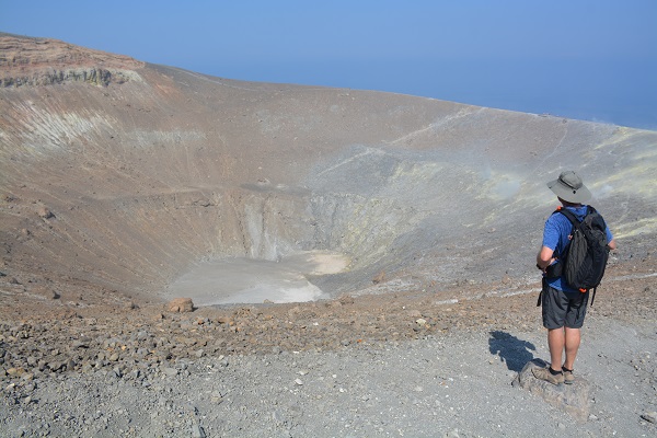
Bob looking into Volcano Crater
Another island nearby also has a volcano that is erupting. This volcano is only releasing gas and steam at this time. We spent the day hiking to the top of this volcano to see it for ourselves. It was fun to see a live volcano up close. We could see where the center crater was when it erupted not too long ago. The fumes coming out were very smelly. It smelled like rotten eggs.

Mount Etna erupting at Night
Courtesy: Nationalgeographic.com
The next volcano we went to is one of the world’s most famous volcanoes. It is called Etna. Mount Etna is located on the Island of Sicily. It is also currently erupting. We drove part of the way up Mount Etna but had to turn back because of the bad weather. Mount Etna is almost 11,000 feet high making it the highest active volcano in Europe. It is so high that there is often extreme weather at the top, such as fog, snow and high winds. A height of 11,000 feet is almost as high as the Rocky Mountains in Colorado.
Signing off,
Bob and Sara Knapp
Latitude: 37° 44’ N
Longitude: 15° 13’ W
—————————————
The Atlantic Project/Quintessa Log #32, 7/2/2015
More Italy – Sicily
Hi Crew,
We were in Rome, Italy when school ended in June. We are still in Italy and are now in the southern part of the country.
When you look at the country of Italy on a map, what shape do you see? Most people look at Italy and see a tall boot with a high heel on it. Before summer we sailed most of the way down the front of the boot. Now we have sailed along the top of the foot, down to the end of the toe and across to Sicily. Sicily is an island. It is the largest island in Italy. Can you locate Sicily on your map?
Sicily is a beautiful island covered with mountains. It has a lot of farming and grows most of the food that people there need. Sicily is known for growing oranges, peaches, grapes, olives, and nuts. Because it is an island they have lots of fresh fish. They eat what they grow and catch. They also sell it to other countries. It is an important part of the economy of Sicily.
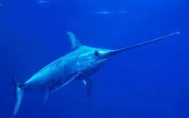
Swordfish with long bill
Courtesy: SeaPics.com
When we sailed on the eastern side of Sicily we saw the boats that fish for swordfish. Do you know what swordfish look like? They are about ten feet long and can weigh over a thousand pounds. They are named because of their long sword shaped upper beak. In Sicily, there is a special type of boat used to catch swordfish. The boats are about 50 feet long which is the same size as our boat. They also have a tall mast, but at the top of their mast is a lookout platform where three men stand. One of the men drives the boat from way up high. The other two are looking for swordfish. Off the front of the boat is a very long walkway, called a bow pulpit. It is actually as long as the boat itself. Another man sits out on the end of the bowsprit with a harpoon.
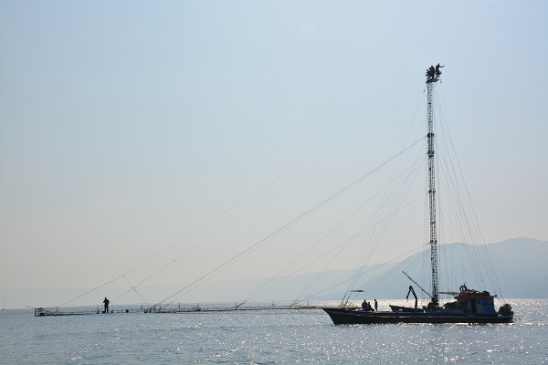
Swordfish boats
Swordfish sleep during the day. When swordfish sleep they swim very slowly near the surface of the water. This lets the men at the top of the mast see the fish. When they do they motor up to the fish. The man on the bow pulpit harpoons the swordfish. We saw about six swordfish boats all moving around us as they were looking for swordfish to catch. It was fun to see the very unusual boats that they use.
The most popular food in Sicily is pizza. There seems to be a pizza shop on every street! You can find pizza with anything you want on top, including vegetables, cheese, fish, hamburger and even salad. The next most popular food is pasta. Most restaurants make their own pasta. We ate a lot of pizza and pasta while we were there. Yum!!
Signing off,
Bob and Sara Knapp
Latitude: 38° 09’ N
Longitude: 13° 23’ E
————————————–
The Atlantic Project/Quintessa Log #31, 6/19/2015
Rome
Rome is the capital of Italy. It is also one of the oldest cities on earth. There is evidence that a town existed there in 753 BC. Parts of buildings from 2,000 years ago are still standing. It is possible to walk through their remains. We visited several of those famous sites.
Probably the most famous ancient site in all of Rome is the Colosseum. It is a large stadium. Gladiators fought there as a form of entertainment. The name “gladiator” comes from the word for “sword”. Gladiators were men who fought wild animals and other gladiators, usually with swords. Sometimes they also used martial arts.

Inside of Colosseum
The Colosseum is set up very much like the football stadium in Foxboro, where the Patriots play. The Colosseum seated 50,000 people, about the same size as Foxboro. Under the floor of the stadium were cages where the animals were kept. The animals included such species as lions, tigers and bears. Many of the animals were brought to Rome from other areas of the world including Africa. This unfortunate practice of fighting wild animals continued up until about 1500 years ago when people became disgusted with it. Fortunately, today people respect animals and this is no longer done.
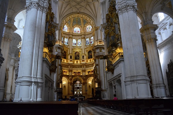
Rome has many beautiful churches and cathedrals. They are filled with paintings and statues, with gold decoration throughout. They are kept open all of the time for people to stop in and visit. We went to about eight churches. They were all different and beautiful. Most of them were very old.
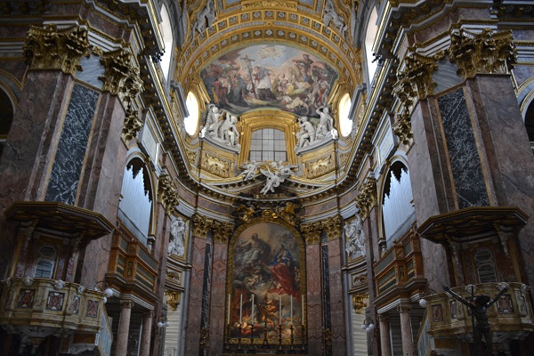
Inside Roman Church
Rome also has a lot of statues and monuments. The Victor Emmanuel Monument is a statue of the first king of Italy. It was built to celebrate Italy becoming an independent country. The statue is gigantic! It is 200 feet high. The statue of the king on his horse is the largest horse statue in the world! The king’s mustache is 5 feet wide. A person could sit inside the hoof of the horse. Think about a statue of a horse that is so big you could fit inside the hoof! To celebrate the completion of the statue they held a dinner party for around 15 people all seated at a large dining table inside the belly of the horse. Isn’t that pretty amazing?

Largest Horse Statue in the World
We also love the fountains in Rome. Many of the parks have fountains with statues that tell a story. The largest and most famous fountain is the Trevi Fountain. It was built 250 years ago. It shoots 24 spouts of water into a wide pool. The statues show Neptune (the god of water) in a chariot shaped like a seashell. His chariot is being pulled by two sea horses. He is riding through his kingdom of water. There is always a crowd at the fountain. It is believed that if you throw three coins into the fountain that your wish will come true. Many people make a wish that they will visit Rome again in the future. We wish that we will someday go to Rome again too!
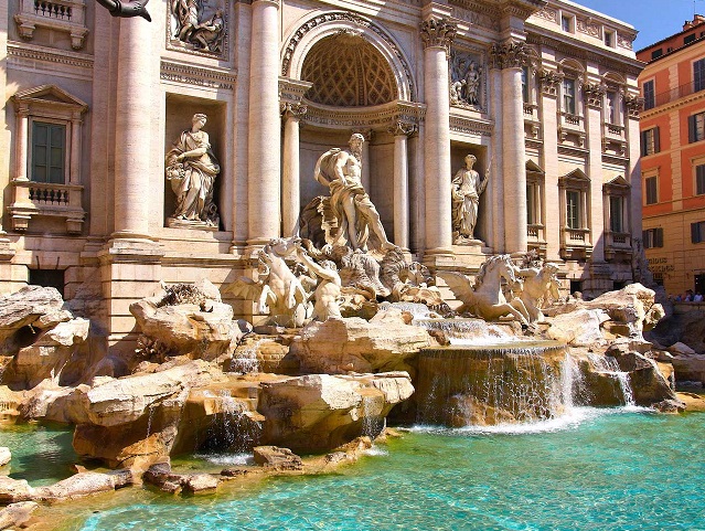
Famous Trevi Fountain
Courtesy: travelroma.com
This will be the last blog for this school year. During the summer we will continue our travelling through Italy and then on to Greece and Turkey. We will send you the blogs from over the summer when you get back to school in September. We wish you a wonderful summer and we look forward to seeing you next year.
Signing off,
Bob and Sara Knapp
(Our position is the same as in the last blog)
—————————————
The Atlantic Project/Quintessa Log #30, 6/16/2015
Naples and Pompeii
Hi Crew,
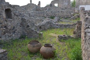
On Friday, we boarded two buses and two trains to check out an ancient city that has been preserved for nearly 2,000 years. The city is Pompeii located near Naples, Italy. Mount Vesuvius, the world’s most powerful volcano is only 5 miles away. When it suddenly erupted, it buried the city under 30 feet of volcanic ash and lava in a matter of hours. It froze the city in time.
Narrow Gauge Train to Pompeii
This is the story of the city of Pompeii: Pompeii was a regular town with 20,000 people living there. That is a little smaller than Andover. It had homes, offices, bakeries, markets, factories, churches and restaurants, much like Andover.
On August 24th, 79 AD, at about 1:00 in the afternoon, Mount Vesuvius erupted.
(How many years ago would the year 79 AD be? What does the abbreviation “AD” mean? What is the difference between AD and BC? If the year was 79 BC, how many years ago would that have been?)
The volcano blew a cloud of gas, ash, and rock more than 12 miles up into the sky. Most of the people who lived in the town of Pompeii left immediately. About 2,000 people stayed in the town, hiding in their homes for protection. When the ash and rocks fell back down to earth, it buried the town and caused the roofs to fall in on the homes, but left the walls partially standing.
Remains of Homes
The next morning the volcano blew even more. This time it sent lava flowing down the sides of the volcano. Lava is a molten rock. It is like a liquid fire running down the sides of the volcano. When it cools, it turns to a solid rock. The lava covered the entire city on top of the ash and caused the city to nearly disappear. All of the people who had stayed in the town of Pompeii died instantly when they were buried under the ash and lava.
Over the past 400 to 500 years digging has been taking place in Pompeii to uncover the city to preserve it as a historical site. They have been able to learn a lot about how people lived 2,000 years ago. Families had vegetable gardens, beautiful paintings on their walls, wooden furniture with upholstery, colorful ceramics and glass tableware. They did not have a lot of things that we have today like electricity, telephones, and cars. Many other parts of their everyday life were like ours today. They went to school. They had sports teams. They had dogs as pets. They even had heated swimming pools!
After we left Pompeii we went to the city of Naples. Naples is a large city in Italy, like Boston. While we were there we went to the National Museum which is all about Pompeii. At the museum we saw all the things that they have recovered from Pompeii. This would include things like pottery, glass, metal work, tools, paintings, and a lot of tile mosaics that were used for floor and wall coverings. We also saw models showing what parts of the city used to look like before the volcano erupted. It was interesting to see how luxurious the homes were and how similar life must have been to life today.
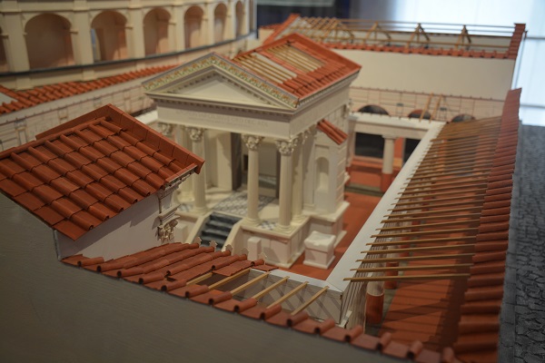
Model of Buildings in Pompeii
Next we went to Rome, Italy where we saw some amazing cathedrals and fountains. We will send you the blog for Rome in a few days.
Signing off,
Bob and Sara Knapp
Latitude: 41° 13’ N
Longitude: 13° 34.3’ E
—————————————
The Atlantic Project/Quintessa Log #29, 6/12/2015
Coast Guard in Italy
Hi Crew,
We are now sailing along the west coast of Italy. Yesterday was a very long day of sailing. For over 14 hours we sailed south along the coast. At 2300 hours we finally got to the area where we were going to stay for the night.
When we say 2300 hours, what time is that in normal everyday time?
(We use “military time” or “24 hour time” on the boat so there is no confusion between AM and PM. Most people on land use normal “12 hour time” which is also called “civilian time”.)
When we got to the exact spot where we wanted to anchor Bob went to the front of the boat to work the anchor. Sara maneuvered the boat from the steering area called the “helm”. Suddenly we saw a large motor boat coming towards us. It was flashing a very bright light on our boat and on our American flag. As it got close we realized that it was an Italian Coast Guard boat.
The boat came along side Quintessa. We both put our fenders out to protect the boats from hitting one another and causing damage. The Coast Guard then tied their boat up to ours. They asked us for our boat documentation and passports. This would prove to them who we were and that we own the boat.
Two of the Coast Guard officers took our paperwork below on their boat. Two other officers stayed on deck with us. The Coast Guard officers kept us for over an hour while they made phone calls and filled out forms. The two officers who stayed with us on the deck of the boat were very friendly. They could speak a little English and we do not speak any Italian. Somehow we managed to communicate with each other. After a while they were both showing us pictures on their cell phones! We found out that their favorite food is spaghetti with clam sauce. One of them loves to fish. He showed a picture of himself with a fish he had caught. The other officer has an uncle who lives in New York City. They both want to learn more English. This was a chance for them to practice.
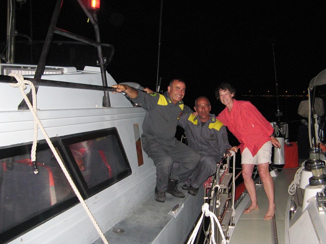
Sara with the Italian Coast Guard
Bob told them about all of you and that you are our crew! He asked them if he could take a picture of them with the two boats tied together so you could see it. They said yes.
The officers who were inside the Coast Guard boat with our documentation finished checking our paperwork. They said it was all correct and we were free to go. We all shook hands and said goodbye. They untied their boat from ours and motored off into the darkness. We then finished anchoring our boat and went to bed. It was a busy ending to a long day.
Almost every country has some form of Coast Guard. You have probably heard about the U.S. Coast Guard. They have several roles. Safety on the water is one of their priorities. They make sure that boats carry the equipment needed to keep everyone safe while onboard. That includes a life jacket for every person, fire extinguishers, signaling devices and emergency pumps.
Can you name some signaling devices that could be used to get someone’s attention?
The next morning we were woken by the sounds of a lot of boat activity. We thought the Coast Guard had returned to check on us. When we looked out we could see that a big work boat called a barge had anchored near us. There was a large crane on the barge and it was digging under the water. This operation is called dredging and it is done to make the area deeper for bigger boats to come and go. In some places the sand and mud fills in over time from ocean currents and storms. It then becomes necessary to do dredging every year or two to keep the water deep enough for the big boats like ferries and cargo ships. It was fun to watch the big shovel drop into the water and disappear under the surface. It would come back up a few seconds later with a big load of dirt that it would dump on the barge. After a little while the barge would be heaping over with mud. It would leave to go dump it into the ocean where it is very deep.
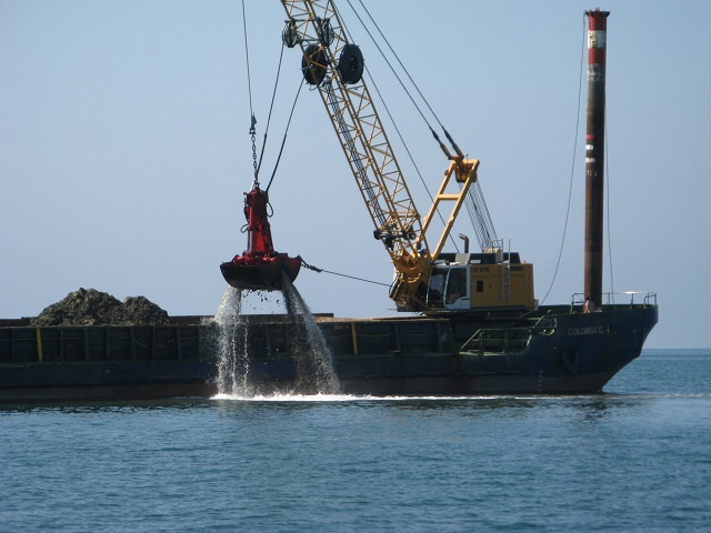
Dredging Operation near us
In a few days we will be in another harbor where we will leave our boat to travel by train to two big cities: Naples and Rome. Both are in Italy. We will tell you all about these two exciting cities in our next blog to you.
Signing off,
Bob and Sara
Latitude: 41° 26.8’ N
Longitude: 12° 38.3’ E
————————————–
The Atlantic Project/Quintessa Log #28, 5/30/2015
Boat Maintenance and Italy
Hi Crew,
We left Barcelona, Spain where we spent the winter. We are now in Italy. Before we left Barcelona we needed to do some work to get the boat ready to sail again. Our boat is like a combination of a house and a car. Like a house, we live in it. It has a kitchen, a living room and bedrooms. Do you remember what those rooms are called on a boat? The kitchen is called the galley, the living room is called the salon, and the bedrooms are called cabins. Like a car, it has an engine and we steer it with a steering wheel. Also like a car, it has to have work done to keep it in good shape.
Last month we had Quintessa pulled out of the water to have the bottom repainted. We do that almost every year. While the boat was out of the water, they discovered that part of the rudder was loose. The rudder is under the boat and is connected to the steering wheel with cables. It is an important part of the boat and allows us to steer the boat. When the steering wheel on the boat is turned, the rudder under the boat turns like the tires on a car. That makes the boat turn to the right or left. We were very surprised to find that it was loose. We were also happy to find it before it became a bigger problem. If the rudder had fallen off the bottom of the boat we would not have been able to steer the boat back to port. It took almost two weeks to fix the rudder. Now it is like new and we are happy to have a safe boat again.
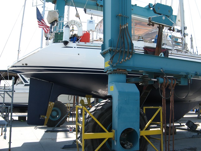
Quintessa’s rudder while hauled out
From Barcelona we sailed across the Mediterranean Sea to Italy. First we stopped at the Island of Elba. It is just off the coast of Italy. We had been there a long time ago on vacation so it was fun to go back again. We then sailed on to the mainland of Italy. We rented a car and went to visit some of Italy’s hill towns.
Hill towns are very old cities built on the top of hills made of rocks. The buildings look like they are carved right into the rocks. Many of the towns were built from around 1000 BC to around 1000 AD. How many years ago is that? That is much older than the United States! People built their towns on the top of the hills to protect themselves from enemies. The enemy could not climb up the rocks to the town very easily. The town would have only one way to get in. They would have a gate that the enemy could not get through.
One town we went to is the town of Civita (pronounced “Cha-VEE-ta”). It is a small hill town. Very few people live there anymore. There are no cars in the town. The streets are too narrow for cars and the only way to get to the town is by walking up a very steep, narrow path. Cars are parked outside the town. The door to enter the town was carved out of rock over 2,500 years ago. All of the buildings are made of stone. The sidewalks and streets are also made of stone. From the town there are beautiful views down into the valleys around Civita. The valleys are filled with areas growing grapes and olives.
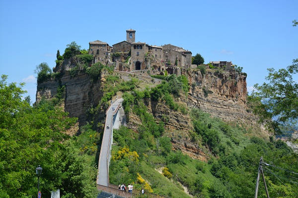
Hill Town in Italy
We had lunch in Civita. We are enjoying eating lots of pasta and pizza here. As you might guess, they make very good pizza in Italy!
On our way to another of the hill towns we drove right into the town. We were following the directions of the voice on the GPS telling us where to turn. We must have taken a wrong turn while we were exploring. Suddenly we found that we were in a street that was so narrow that we had to pull in the side mirrors on the car to not scrape them on the fronts of the houses on both sides of us. Yikes! What would you have done if you were in the car?
Fortunately Sara had gotten out of the car just before the road got so narrow. That was a good thing. Once we were wedged into the small space she could not have even climbed out of the door window.
Sara guided Bob while he drove backwards, up a hill, and back out onto the main street. It was very close. We had less than 1/8th inch on each side of the car at one point. It took a lot of going back and forth to make the turns. We managed to get out without even a scratch on the car. Whew!
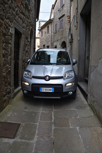
Car stuck in tight street
After we left the hill towns we drove back to the marina where we had left Quintessa and sailed back to Elba. We will be here for a few days doing more boat projects, while we get ready to sail down the coast of Italy.
Our next blog to you will be from another part of Italy. Our current location in Elba is:
Signing off,
Bob and Sara
Latitude: 42° 48.5’ N
Longitude: 10° 19.0’ E
————————————–
The Atlantic Project/Quintessa Q&A, 4/30/2015
In April, the fourth graders wrote out questions for Sara and Bob. Included below is a transcript of the questions together with answers:
Q – Have you ever gone to a bullfight in Spain? (Ethan)
A – Bull fights are still very popular in Spain. We have not been to a bullfight in Spain because they do not have a happy ending. In Spain the bull is killed at the end of the fight and we believe that is not right. In some other countries, like Portugal, the bullfight is still very exciting and colorful, but the bull is not killed. Instead, the bull lives to a happy old age.
Q – Have you planned on going to Romania? (Andrei)
A – We will not be going to Romania by boat while we are in the Mediterranean. It is possible to get there from the Mediterranean Sea but hat would be by going through a canal in the center of Istanbul, Turkey, and sailing across the Black Sea. Romania is located on the Black Sea.
We will be doing some travel by train and bus. We may go to Romania sometime before we leave the Mediterranean area. We have heard that it is a very beautiful country. Andrei, do you have family in Romania?
Q – Do you like cheese? (Henry)
A – We love cheese and all different types of cheese! As we told you when we talked about foods of the Mediterranean, many kinds of cheese are made in countries around the Mediterranean and shipped to other countries, including the United States. Can you remember some of the cheeses?
Blue Cheese – France
Mozzarella and Parmesan cheese – Italy
Swiss cheese – Switzerland
Gouda – Holland
Feta – Greece
Cheddar – United States
Manchego – Spain
Can you think of others to add to the list?
What is your favorite type of cheese?
Q – What was your favorite food from different places and why? (Emmaleigh)
A – Bob’s favorite food in Spain is Jamon. That is the prosciutto type of smoked ham from the leg of the pig. Do you remember the photos of the smoked jamons hanging from the ceiling in a store?
Sara’s favorite food in Spain is olives. She likes all of the different types of olives. She likes the way they are marinated for more flavor in Spain and are not as salty.
In France, Bob’s favorite food is crepes. He likes them with ice cream in the middle and chocolate sauce on top. Sometimes in France you can get crepes with cheese in the middle as a main course. Bob likes those too, but his favorite is the ice cream dessert crepes.
In England, Bob’s favorite food is what is called the full English breakfast. It is 2 fried eggs, 2 sausages, baked beans, toast, and a grilled tomato. It makes a hearty, filling breakfast. When we lived in Andover, Bob would cook it for guests and himself occasionally.
Sara’s favorite food in England was fish and chips. You have probably all seen or tasted that. It is fried fish served with French fries. French fries in England are called “chips”. Potato chips are called “crisps”.
We are now looking forward to going to Italy in a few months and trying pizza there. You will still be in school when we get to Italy so we will let you know what the pizza is like in Italy!
Q – What was your most unique food you had on your voyage? (Freddy)
A – Sara would say octopus was her most unique food. It is usually cooked and cut into small pieces and put into a salad or pasta. Sometimes it is served as the whole octopus but without the head. Bob said that sea urchin was his most unique food. He thought it tasted like the ocean. We had each not tasted those foods before we came to Europe.
Q – What was your favorite place you visited? (Freddy) (Devon) (Ellie) (Miella)
A – Bob’s favorite places are Ville de France and Nice (pronounced “Niece”) along the coast of France. They are side by side. The area where we anchored the boat had beautiful scenery around it. The village of Ville de France is very old. Some of the buildings are over 400 years old and they are on the side of a very steep hill. We walked up about 300 steps to get to the top of the hill where we got the bus to Nice. The city of Nice has pretty flower markets and a nice waterfront.
Sara’s favorite place is Barcelona, Spain where we have been living for the winter. It is been fun to spend a longer time in one city to meet people who live here. We have made a lot of new friends. We have also learned our way around the city. We have had time to visit more museums and go to concerts. You learn more about an area when you do daily things like go a grocery store and see what people have available for food. You learn what they see on television and the type of music they listen to. We are surprised to hear so much American music, all in English. Many television shows are American shows that you see in Andover. Here, the voices are changed to speak Spanish.
Q – How hot was it in Paris? (Claire)
A – We were in Paris in December for Christmas. The weather in Paris is very much like the weather in Andover, so it was very cold and we saw some snow. We wore our winter coats, hats, and gloves.
Q – What was your favorite food place to go? (Megan) (Kendal)
A – We both liked going to the open markets in each country where lots of different foods are sold in one huge open building. We tried many new foods. We learned about the special foods of each country. We tasted octopus salad in Portugal. In France we tried some special cheeses. In Spain we had special small sausages with small green peppers made into a pincho. Do you remember the picture of pinchos? They are the foods served on a big toothpick.
Q – What will it be like in Scotland? (Maitrayan)
A – It was cool and rainy in Scotland. We went to Edinburgh, the capital where we visited the castle and a museum about the history of the city. We also visited the Britannia, the ship that used to be owned by the Queen of England. She and her family spent weekends and vacations on board the ship. It was the Queen’s favorite place to spend weekends. Some day we would like to go back to Scotland and see more of the country.
Q – Have you been to Greece? If not, go to Athens, Kalamata, or Xanthi. (Dino)
A – We have not been to Greece yet, but will be going there this summer. Visiting Athens is in our plans. The area is filled with important history. We are looking forward to learning a lot about Greece. Did you know that the Olympics started in Greece? We may be near Kalamata but will not make it to Xanthi, which is very far north in the country. Dino, did you tell us your grandfather is from there? We will send you a blog from Greece while we are there. You will all just be getting back to school from summer vacation at that time.
Q – Have you ever seen Branscombe, England? (Matt)
A – We have never been to Branscombe, England. I looked it up and see that it is very close to the Ocean on the south coast of England. Matt, your family name must have come from there.
Q – What did you use to open the urchins? (Hannah)
A – The woman we bought the urchins from opened them with a special type of scissors that were in the shape of a ring. Most of the inside of the urchin looks empty. The parts you eat are five small orange bands right under the shell. You scrape it out to eat it using a small spoon. You eat the urchin uncooked.
Q – What time is it in Spain? (Hannah)
A – Spain is six hours ahead of Andover. So when it is 1:00 PM in Andover, it is 7:00 PM in Spain. Spain has daylight savings time like the United States does.
Q – What was the most challenging thing on your trip? (Anthony)
A – The most challenging part of the trip was weather forecasting and planning. When you sail on the open water, especially the ocean, you have to know what the weather and waves will be the entire time you are out. We spend part of every day studying the weather. It is important, for safety, to not sail when the conditions are going to be too great. High winds can also cause very high waves that make it both uncomfortable and unsafe for the boat. We are very careful about studying the weather reports so we have very rarely gotten into trouble.
Q – What was your favorite place in Paris? (Abby)
A – Our favorite place was the Louvre Museum. It is the largest museum in the world. It has some very famous paintings, including the Mona Lisa. It would be easy to spend all day, every day for weeks at the museum and still not see all of the paintings, art work and artifacts there. We spent just one day there and really liked it. We would like to go back there again someday and see more of the museum.
Q – Did you go through the Bermuda Triangle on Quintessa? (Alex)
A – Yes, we did sail through the Bermuda Triangle. We have been there both on Quintessa and on our last boat too. There are several different definitions for the location of the Bermuda Triangle. The most common points making up the triangle are: Miami, Florida to San Juan, Puerto Rico to Bermuda. Can you find those points on a map that make the triangle?
There are some people that say the Bermuda triangle is cursed because of all the ships and planes that have gone down in this area. Then, the stories are told and retold over and over and get blown out of proportion. We believe the reason there are so many bad stories of this area is because it is an area of especially bad weather. We are not afraid of the Bermuda Triangle. We will sail there again but we are always extra careful to check the weather.
Q – What was your longest trip? (Rishika)
A – Our longest trip without going to land or getting off the boat was sailing from Bermuda to the Azores. It was over 1,000 miles, and took us 11 days. We had two friends on the boat with us to help because we sailed all day and all night. When we do that we take turns being “on watch”, where someone always stays awake to keep an eye on things. For safety, we never all go to sleep at the same time. Someone is always responsible for the safety of the crew and the boat.
Q – What is your favorite part of your trip? (Benjamin) (Diya) (Rishika)
Our favorite part of our trip is arriving in a new country where we have never been before. We love seeing new places, learning about how people live in other countries, what their customs are, and meeting new people. We learn about how people dress, what they eat, where they go to school, and what kinds of work they do. Some countries are very similar to ours and others are quite different. When we see you at school in November we can talk about what is the same and what is different between countries. The differences can be lots of fun. For example, in England and Bermuda, people drive cars on the left. In the United States we drive on the right side of the road. In the United States, most students do not wear uniforms to school. In the Bahamas, Turks and Caicos, and Bermuda, all students wear uniforms to school. In Europe the cars are smaller and there are a lot of bicycles and motor scooters. In Barcelona and some other countries the bicycles ride on the sidewalks in special lanes and the sidewalks are made of tiles like you might have inside a building.
Q – Have you ever gotten sea sick? (Luca)
A – Bob has never been sea sick but sometimes feels queezy. Sara was sea sick on the first night we left Bermuda to sail across the Atlantic. It did not last long. She was fine by the next day and for the rest of the trip. She has not been seasick since then.
Q – What was the scariest part of the journey? (Sam)
A – The scariest day was getting caught in a storm off the coast of France. We wrote about it in one of our blogs to you. We were anchored near a small town. A storm came up very quickly that had not been forecast. The wind blew over 50 knots, which is very high. There was hail the size of ice cubes hitting the boat and us. We went inside and closed the door and windows. It rained so hard that we could not see any other boats around us. We were worried about the boat dragging onto the beach, or the rocks, or hitting another boat. After about 40 minutes the wind and rain suddenly stopped and the sun came out. The boat had been dragged by the wind and waves for almost a quarter of a mile. We started the engine, pulled up the anchor and moved the boat back to where it had been before the storm. We then reset the anchor. We were both fine and the boat only had minor damage. It was scary but we were very lucky!
Q – How do you choose where you go? (Sam)
A – We choose where we go based on several things. First, which countries or cities do we want to see and learn more about. Then we look at the charts (maps) for the best way to sail there. We figure out how far it is from where we are now. That lets us know how long it will take. Sometimes that is only a few hours. Other times it is a few days. Finally, we look at the weather to see if it is a safe time to go. If not, we wait until the weather gets better. Safety is always most important when planning our trips.
Q – Did you visit Disneyland in Paris? (Alyssa)
A – We did not go to Disneyland in Paris. We did not have time. Bob has been to Disneyworld in Florida but Sara has never been there. We both went to Epcot Center in Florida when we sailed through northern Florida.
Q – How many postcards have you sent us and are you really visiting us next month? (Myranda)
A – We have sent lots of postcards over the past 2 years. We have not kept track but extimate that we have sent 25 postcards to your classes. You have no doubt seen many of them are on the bulletin board in the hallway outside your classroom. We will send more postcards as we continue our trip. Since we were in Barcelona all winter there were not many new places so we have not send as many recently. In another two weeks we will begin sailing again and will be sending more postcards from the new countries. This summer we will be sailing to Italy, Greece, and Turkey.
Q – Have you ever seen a sea cow? It is also called a manatee. Also, have you ever seen a shark?
Have you seen a great white shark? (Charlie) (Eduard)
A – There are lots of manatees in Florida. It is the only place we have seen them. They are large and very gentle animals. In Florida they swim near the boats looking for fish in the water. They should never be fed by humans. Manatees eat up to 100 pounds of water plants every day. They are about 10 feet long and can weigh over 1,000 pounds. Florida has speed limits for boats to protect the manatees. A number of years ago one manatee swam all the way to New England. His name is Chessie because if fist showed up in the Chesapeake Bay. We sent a book on the adventures of Chessie to your classroom two years ago. Ask your teacher to help you find the book and you can read the story yourself. For a update on Chessie you can check out the link below. It is a very warm and funny story:
http://www.oceanicresearch.org/education/wonders/chessie.html
We have seen several sharks and have even swam with some called nurse sharks. Nurse sharks are not aggressive and will not bother humans. We have never seen a great white shark.
Q – Have you seen any big or strange sea animal throughout your trip, such as whales or squids? (Annaya) (Max)
A – In the middle of the ocean on our trip across the Atlantic we saw two whales in two days. The first whale was about a half mile from us. We could see it blow water into the air through its blow hole. It uses the blow hole as part of breathing. The next day we had a whale come up out of the water right beside the boat. It was only about ten feet from the boat and was as long as the boat. Both times the whale just swam on by and kept going.
Q – Have you ever fallen off the boat?
A – Bob fell off the boat, but only one time. We had just bought a new system, called a “pasarelle”. It is a plank, attached to the back of the boat made for walking off the boat onto the dock. It is often used in the Mediterranean when there is not a dock beside the boat to step off onto. The ropes we used to attach the pasarelle to the boat were too thin. When Bob stepped onto it, the palsarelle swung to the side and Bob to the other. Into the water he went. Later that day we went to the boat supply store and bought stronger ropes. No one has fallen in since!
Q – Have you ever dropped any of your stuff in the sea? (Asher)
A – Both Bob and Sara have dropped our good sunglasses into the sea. Bob had climbed up the mast to the very top to do some work and his sunglasses fell off. They dropped all the way from the top of the mast to the bottom of the sea. We never found them. Sara leaned over the side of the boat and hers fell off. We both learned from that expensive lesson. Now we both wear straps on our sunglasses so if they fall off, they stay attached to us.
Q – How old is your boat? (Lily)
A – Our boat, Quintessa, is 11 years old.
Q – How many total miles have you traveled so far by boat? (Kathleen) (Henry)
A – Since leaving New England we have traveled a total of 26,600 nautical miles. This includes going in and out of places. Our route, going from major point to major point, has been slightly over 7,000 nautical miles. As you may remember from reading our blog, a nautical mile is slightly longer than a regular (statute) mile. Therefore, if you convert to regular miles the route has been slightly over 8,000 statute miles. Do you know how to convert from one to the other?
Q – What was the hardest part of the trip? (Braeden) (Sammy)
A – For Sara, the hardest part of the trip was saying goodbye to her family, because she would not see them for a long time. We fly home twice each year to see them, but we miss them a lot. We have now set up skype so we can talk to them more often. That is fun.
Q – How long did it take to sail across the Atlantic Ocean? (Kate)
A – It takes about 5 days to sail from Boston to Bermuda, then 11 days to sail from Bermuda to the Azores and, finally 6 more days to sail from the Azores to Lisbon, Portugal. We were then all the way across the Atlantic. How many days does that add up to?
Q – What was your favorite food place to go? (Kendal)
A – Spain is probably our favorite food place so far. We love the fresh oranges, olives, and jamon that all come from here. Tapas, which are the small plates of food, let us try out lots of new types of food.
Q – What was the degrees in Paris? (Aidan)
Aiden, there are two answers to that question. The first is the degrees of temperature. It was only about 35 degrees Fahrenheit while we were in Paris, which is cold but typical weather in Paris in December. Paris weather is like weather in Andover, but Paris has less snow. Of course in Europe they do not use Fahrenheit for temperature, they use Celcius. In Celsius the temperature in Paris would beabout 2 degrees. Do you know how to convert from one to the other?
The second answer about the degrees in Paris refers to the latitude and longitude of the city of Paris on the earth. Paris, France is located at: 48° 51.2′ N Latitude by 2° 20.9′ E Longitude.
————————————–
The Atlantic Project/Quintessa Log #27, 3/19/2015
London and Edinburgh
Dear Crew:
A few weeks ago we went to London, England; and Edinburgh, Scotland. They are both located in the United Kingdom. Can you find that on a map? What other countries make up the United Kingdom? What direction is that from Andover? We flew to London from Spain. In what direction did we fly to get there?
London is the capital of England. It is a very large and busy city. At one time, less than 100 years ago, this city ruled over one quarter (25%) of the world’s population. Everyone speaks English in the UK. That makes it easy for us to talk to people. We walked or took the subway everywhere we went.
The museums in London are very good. We spent one day at the Victoria and Albert Museum. It is named for a former King and Queen of England. The museum had a special display of wedding dresses. Some of the dresses are over 200 years old. They showed how styles have changed over the years. Wedding dresses are very expensive. Many years ago girls had dresses made that they could wear again after they were married to save money. We also learned that girls did not always wear white wedding dresses. After Queen Victoria wore a white dress for her wedding, other girls started to do the same, and that color has been popular ever since.
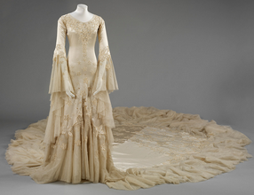
Old Style Wedding Dress
Courtesy: Victory and Albert Museum
The most popular tourist attraction in London is the London Eye. It is a giant Ferris wheel. It is 443 feet tall and the tallest Ferris wheel in Europe. It was built in 1999 to celebrate the new century. The wheel has large cars shaped like capsules with windows all around. Each car holds 25 people. The cars move very slowly, so it takes 30 minutes to go all the way around once. It actually doesn’t stop. It goes so slowly that you just step out of the car and onto a moving platform when it is time to get off. To get in, you step into the slowly moving car while the door is open. From the cars on the wheel you can see all across the city of London as the wheel goes around.
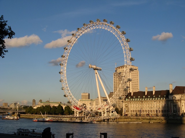
The London Eye
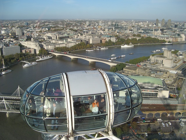
View from Top
From London we took a train north to Edinburgh, Scotland. Edinburgh is the capital of the country of Scotland. From the train we were able to see the countryside of England and Scotland. There are many small towns and farms along the way. There were also lots of cows and sheep.
The most famous place in Scotland is Edinburgh Castle. It is in the middle of the city of Edinburgh, and sits high atop a hill of steep rocks. The castle is over one thousand years old. The steep rocks helped to protect the castle from enemy armies. No one has tried to invade the castle in the past 300 years. It is still a military base today. From the castle on top of the hill, you can see a long distance, including to the harbor where boats arrive. Many Kings and Queens have lived here over the years.

Edinburgh Castle
Every day, except Sunday, at 1:00 PM a large gun on wheels is fired from the wall of the Castle. It is only fired with blanks but it makes a loud BANG. This practice was originally started to help ships in the harbor reset their clocks. Everyone in town knows that it is 1:00 too. The gun looks like a modern-day cannon.
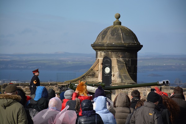
Gun for Sounding Time
While we were in Edinburgh we visited Her Majesty’s Yacht Britannia. It is the former royal yacht of Queen Elizabeth of England. The ship is 400 feet long, which is a very large boat! It was built for the Queen and her family to spend weekends and vacations on board. They also used it to travel from England to other countries, including the United States, for diplomatic missions. Four different American presidents have been guests on the ship. The Britannia traveled over a million miles while the Queen owned it. She owned it for over 40 years. Britannia was also built to be used as a hospital ship if a war broke out. Fortunately it never had to be used as a hospital ship. The Queen does not own the ship anymore. It is now open for tourists to visit. The Queen used to stand in the center of the top deck right behind the railing to wave to the crowd when coming into harbor.
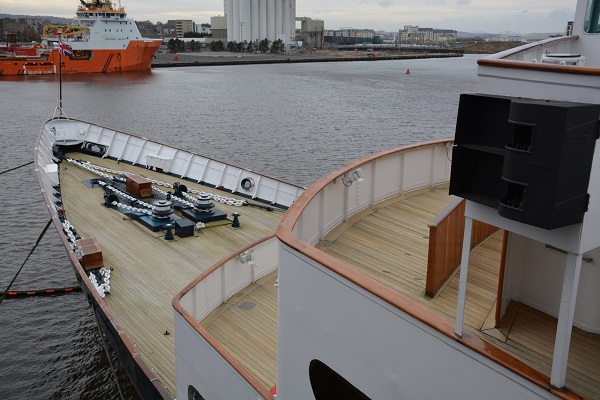
Bow where the Queen Stood
The next time you hear from us we will be sailing again. Our first stop will be some large islands off the southeast coast of Spain. From there we will be going to France and then Italy.
Signing off,
Bob and Sara Knapp
————————————–
The Atlantic Project/Quintessa Log #26, 2/28/2015
Madrid, Spain
Dear Crew:
We are still living in Barcelona, Spain on our boat. We have been here all winter. The weather here is like spring in Andover all winter long, so we have not had any snow! We hear that you have had the most snow you have ever had.
Do you remember where the country of Spain is located? What continent is it on?
We took a train to the city of Madrid for a weekend. It is the capital of Spain. Madrid was made the capital of Spain in the year 1561. How many years ago is that? Madrid is located in the middle of the country.
Madrid and the area around it have some of the finest royal palaces and gardens in Europe. The palace in Madrid was built 250 years ago and was where the King and Queen used to live. It has 2,800 rooms inside. You will always know what time it is when you are there. The palace has a total of 215 clocks!
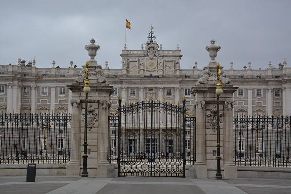
Palace in Madrid, Spain
People in Madrid love their “football” team. What we call soccer in the United States is called football in most other countries, including Spain. People in Madrid get very excited when their team is playing. The team is named “Real Madrid”. They are one of the best soccer teams in the world. They play against teams from countries on the continents of South America, Africa, Europe and the Asia. Can you find those continents on a world map? When their team is in the finals most years, everyone watches the games on TV. It is such a big event that sometimes the stores close so people can go home to watch the games. During the soccer season many people wear a Real Madrid team shirt to show their team support like some people in Andover wear shirts for the Patriots or the Red Sox.
Another popular event in Madrid is bull fights. A man, called a “matador” waves a bright cape in front of a bull to excite the bull. It is considered an art and sort of dance between the bull and the bullfighter. In some bullfights, the matador then has to get close enough to the running bull to grab a ribbon from between the long horns of the bull. The top matadors in Spain are as famous as Tom Brady.
In Madrid, like in Barcelona where we live now, people like to be outside. Spain is a very sunny country. Many restaurants have outdoor tables and seats, even in cool weather. People meet friends for coffee or lunch and sit outside to enjoy the sunshine together.
Madrid also has a wonderful food court, similar to open markets which we have reported to you in other cities, but with all prepared food which is ready to eat. Bob tried the Sea Urchins which is considered a delicacy. He said it was very strange eating seafood with spines but you don’t actually eat the outside. He said it was: “sort of good”, “tasted like the ocean“.
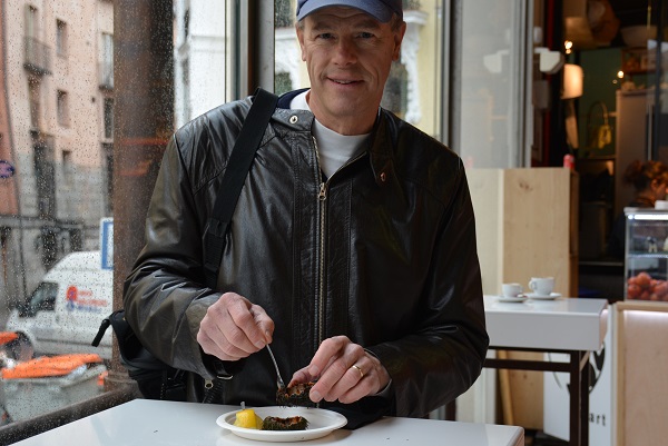
Bob eating Sea Urchins
One day we had lunch at a restaurant that is 290 years old. The Guinness Book of Records says it is the oldest continually operating restaurant in the world. We sat at a table in the basement. The walls are brick on the inside and the floors are made of stone. A lot of the food is cooked over a wood fire in an oven called a “brick oven”. A brick oven is sort of like a pizza oven and the food is slid in through a small opening or door.
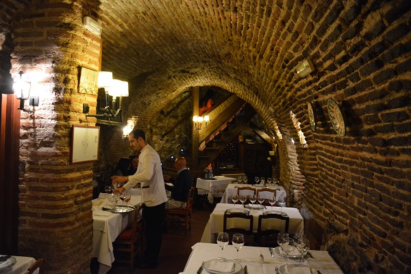
Dining Room in Oldest Restaurant
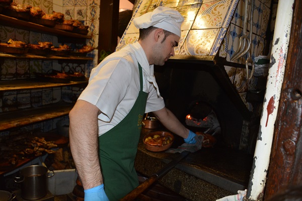
Brick Oven for Cooking
Our next winter trip will be to London and Scotland and we will report on that next month.
Signing off,
Bob and Sara Knapp
————————————-
The Atlantic Project/Quintessa Log #25, 1/15/2015
Paris, France
Dear Crew:
One of our goals for the winter season is to do land travel to some new places and learn about them. So, at the end of December we travelled to Paris, France. Paris is the capital of France, like Washington, DC is the capital of the United States. Can you find Paris on your world map? It is about two-thirds of the way into France going north from Spain. What are the other countries that boarder France? Can you locate the famous river that runs through France and goes right through the middle of Paris? What is the name of it?
In Paris we saw many of the sights that Paris is known for. We stayed in a hotel that was located on the Champs Élysées. The Champs Élysées is the most famous street in the world. It is a French word that means “fields” which is what the street used to be. The name is difficult to say. In French, it is pronounced: “shah-zay lee-zay”. Try saying the word. Do you know any other French words? Did you notice the word has marks over the letter “e”? These are called accents. The French language uses a lot of accents in the spelling of words.

Champs Élysées with Holiday Lights
At one end of the Champs Élysées is a famous landmark. It is the Arc de Triomphe. It is a huge monument, the size of a building, in the center of the city in the shape of an arch . Many major streets radiate out from the Arc de Triomphe like the spokes of a bicycle wheel. The Arc de Triomphe was built over 200 years ago to honor France’s military victories and the people who fought in the wars.
We also visited another popular monument in Paris, the Eiffel Tower. The Eiffel tower is recognized all over the world and is the most famous building in Paris. It was built over 100 years ago for the Worlds’ Fair which was held in Paris.
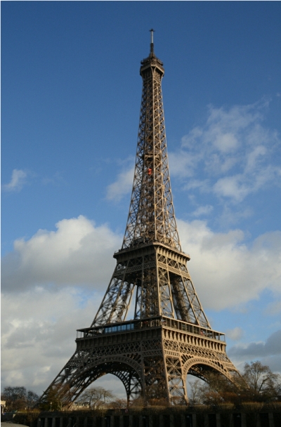
Eiffel Tower
At the other end of the Champs Élysées we visited the Louvre Museum. It is the largest museum in the world and one of the most famous. It is so big it would take more than a week to go through the entire museum. The Louvre is home to one of the most famous paintings in the world, named the Mona Lisa. Do you know who the artist was that painted the Mona Lisa?
The river that runs through Paris is the Seine River. On a Small Island in the middle of the river is a very large and famous cathedral. It is the Cathedral of Notre-Dame. Notre-Dame was built over 800 years ago. It took almost 200 years to build.
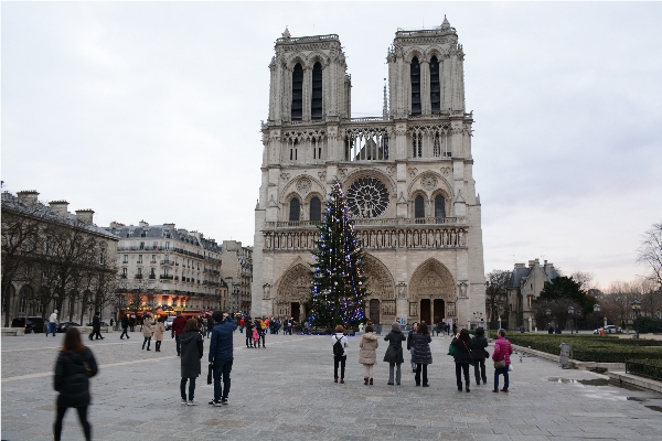
Notre-Dame Cathedral
Paris, France is called the “city of lights” because it was the first city in Europe to have street lights. We loved being there with the holiday lights all lit up and colorful. It really is still the city of lights today! Our next land trip will take us to London, England and some other places in Great Britain. We will report to you on Great Britain the end of next month.
Signing off,
Bob and Sara Knapp
Position: (Currently in winter marina in Barcelona so no latitude/longitude provided)
————————————–
The Atlantic Project/Quintessa Log #24, 12/15/2014
Holidays in Spain
Dear Crew:
We are back in Spain after our visit to Andover. It was wonderful to see all of you and to meet Mrs. Plomondon and Mr. McCall’s fourth grade classes. You are new members of our land based crew for the next year.
During the winter most boats do not go sailing in the Mediterranean. It is cold here, but not as cold as in Andover. There are also more storms here in the winter with high winds and waves. Boats stay in marinas for the winter. They start sailing again at the end of April when it is warmer.
Our boat, Quintessa, is at a marina in the city of Barcelona, Spain. We are living on the boat for the winter. Because we are right in the city we can walk or take the subway almost anywhere. We do not need a car.
Being in Spain is giving us a chance to learn to speak Spanish. We are also trying lots of Spanish foods and learning about their holidays. Spain does not celebrate Thanksgiving as we do in the United States. Do you know why? What does Thanksgiving celebrate?
It is now Christmas and Hanukah in Spain. There are lots of colored lights and decorated trees all around the city. They have different traditions in Spain than we do in the United States. For Christians, their big holiday is not on Christmas Day. On that day they have a big family dinner and go to visit family and friends. On Christmas Eve, instead of stockings, children put logs out that are hollow on the inside. They are called “Poop Logs” or Tio de Nadal which means Christmas Log. On Christmas eve children gather around and hit them with sticks to open them up. Inside the logs the children find small gifts.
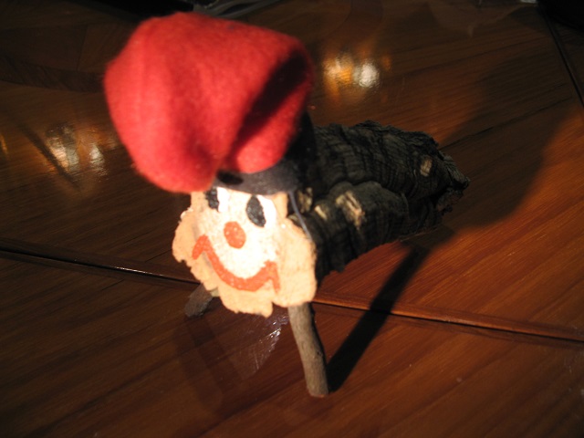
Tio de Nadal (Christmas Log)
The big holiday of the season here is on January 6 which is called Feast of the Epiphany. It is the day the Three Wise Men come to present gifts. They arrive in the city the day before by boat. Then they ride on a float in a large parade through the city. People throw candy from the floats to children watching the parade. That night children go to bed early. In the morning there are their big gifts for the holiday season. That day families get together. They have a special big dinner to celebrate.
New Year’s Eve people gather for a large dinner with their families. After dinner they go out with their friends. Many people wear red underwear on New Year’s Eve. Then, just before midnight as the clock begins to strike twelve times, they eat a grape with each strike. Both customs are considered to bring good luck in the New Year.
What does your family do to celebrate the holidays this season? Do you have a favorite thing that your family does together?
We wish you a very happy holiday and wonderful New Year. Enjoy your vacation!
Signing off,
Bob and Sara Knapp
Latitude: 41° 22.8’ N
Longitude: 2° 11’ E
—————————————
The Atlantic Project/Quintessa Log #23, 11/5/2014
Corsica and Menorca
Dear Crew:
When we left the south coast of France we sailed all night to the island of Corsica. Corsica is part of France but is about 100 miles away in the middle of the Mediterranean Sea. Everyone speaks French. The island is actually closer to the coast of Italy than to France. Because it is close to Italy, many people have moved there from Italy. They have great pizza!
There is a walled city along the coast that was built to protect the people of the island from invasions. Inside the walled city are very old homes and narrow streets with a large church right at the top. It is called a citadel. When the enemy army came, the doors to the city would be closed and the enemy could not get in. That kept everyone safe.
Citadel with high walls
The area where we anchored our boat is a beautiful bay with tall rocky mountains all around it. It is very crowded in the summer with lots of boats and tourists. Now it is fall and many people have put their boats away for the winter. We were the only boat here. Boating and tourism create most of the jobs here. There are many restaurants. There are also a lot of hiking trails around the island and up into the mountains.
The famous French ruler, Napoleon, was born in Corsica. He lived here with his parents until he was ten years old. His family then moved to another part of France. There are a lot of statues of Napoleon honoring him.
The coast of Corsica is very rugged. There are cliffs of rock all along the coast with no beaches. In many places along the coast it would be impossible to get on to shore from a boat because the cliffs of rock are so high. There are also very few towns. Most of the island is tall mountains and rock.
The towns we visited are similar to Andover. There are schools and churches, parks and playgrounds. Most families live in apartments without yards so the kids use the playgrounds. They have some cool equipment on their playgrounds. One of the best things is a five sided cube with rock climbing hand holds all around it. The sides are at different angles which make it hard to do. It is like climbing up the side of a mountain.
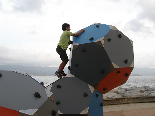
Rock climbing cubes
From Corsica we sailed almost 200 miles to Menorca. That took two days and one night. Menorca is another island in the Mediterranean, but it is part of Spain. People there speak Spanish and are very friendly.
Menorca is a vacation area for many people in Europe and England. It has good weather most of the year. The roads are very narrow. Many of the roads have high stone walls along the sides of the road. The coast is rocky so there are very few sandy beaches.
We saw many dogs in Menorca. Dogs are very popular and go everywhere, even in the outdoor restaurants. There are also hundreds of cows in Menorca. Menorca makes excellent cheese. They sell the cheese on the island. They also ship cheese to other countries.
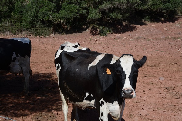
Cows for cheese production
Next year we plan to come back to Menorca and do more exploring of this lovely island. We will be sailing here from the Barcelona which is north-west of here.
Quiz question: If we will be sailing from Barcelona, Spain to Menorca, what direction will we need to steer? What approximate compass heading would that be?
Signing off,
Bob and Sara
Latitude: 39° 53.5’ N
Longitude: 4° 16.5’ E
————————————–
The Atlantic Project/Quintessa Log #22, 10/9/2014
More France
Hi Crew:
We are still in the country of France. Once of our favorite cities is Nice. It is pronounced like “Niece”. Now when we think of Nice we think of flowers. Millions of flowers are grown all around the city. They are sold in the market. It is fun to walk through the market and see so many beautiful flowers all for sale. In addition to selling flowers to look at, flowers are also used to make soaps that smell like flowers. We visited a small soap manufacturer and watched the soap bars coming out of a machine. Along with soap making, another major industry in Nice is the making of perfumes. The perfumes are sold all over the world. The flowers create a lot of jobs for people.
Soap Manufacturing
Part of the city is on the side of a steep hill. Some of the streets are just steps going up the side of the hill. Cars cannot go on those streets. They are just for people. To get to the bus we walked up a street of over 300 steps to get to the bus stop.
Step Sidewalks
The French Alps are a group of mountains in France. They are a few hours from Nice. We took a train from Nice into the Alps to see some very old villages. From the train we saw where the flowers grow.
We stayed overnight in one of the villages. The home we stayed in was built in the 1500s. That means the house is over 500 years old! At the top of the hill in the village is a citadel. That is a large fort. At the bottom of the hill there is a high stone wall around all of the houses. It has a gate with a drawbridge to get into the village. When the drawbridge is pulled up and closed, no one can get into the village. Many years ago it was used to protect the village from enemies.
Drawbridge into Old City
When we left Nice, we sailed to the country of Monaco, which is only ten miles away. Monaco is on the Mediterranean Sea and is surrounded by the country of France. People in Monaco speak French. Monaco is one of the smallest countries in the world. It is also one of the richest countries in the world. The entire country is much smaller that the town of Andover.
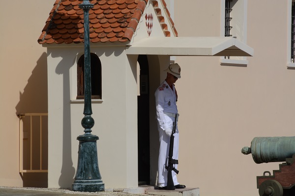
Guard at the Monaco Palace
The government of Monaco is called a monarchy because it is run by a royal family. Prince Albert is head of the country now. His family has led Monaco for over 700 years. He lives in a palace there. The palace and most of the country are built on a steep hill. Our boat was docked just below the palace. We could see the palace from the marina. That was pretty cool.
Next we are leaving the coast of France to sail to the island of Corsica in the middle of the Mediterranean Sea.
Signing off,
Bob and Sara Knapp
Latitude: 43° 43.7’ N
Longtude: 7° 25.3’ E
—————————————
The Atlantic Project/Quintessa Log #21, 9/30/2014
France
Dear Crew:
Bonjour!
Do you know what that means? It means “hello” in French. We are now in France where people speak French. Bob is learning French. He wants to be able to talk to people here. In school students are taught several languages. Most learn English as well as French. Some people like to practice speaking English by talking to us. It is fun for us too. We practice our French by talking to them. It is a good way to learn a new language. In France a lot of the movies and music are in English too. Most signs and menus at restaurants are in both languages.
France has two coast lines. The Atlantic Ocean is to the north. The Mediterranean Sea is to the south, where we are. The countries beside France on the Mediterranean Sea are Spain to the west and Italy to the east. It is very easy for people to travel between the countries. Also, everyone uses the same currency or money. It is called the Euro. The Euro is like our dollar.
Quiz question: When we write an amount in dollars we use the “$” symbol. What is the Symbol for the euro? How it written differently than with dollars?
Mussels and Shrimp
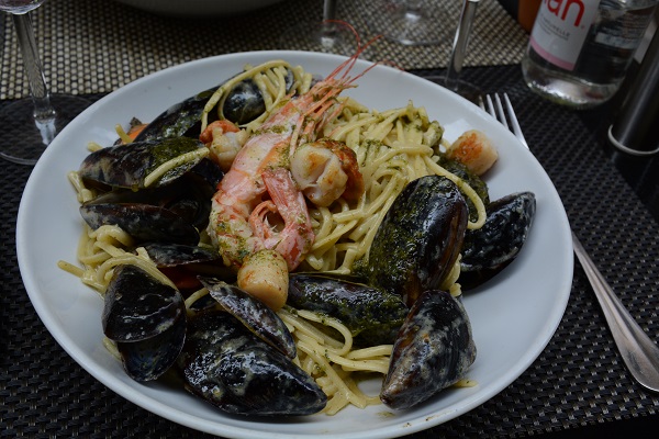
The food in France is similar to our food. French people eat a lot of seafood including the local mussels and shrimp. Mussels are a type of shell fish. They are similar to the mussels we have in New England only smaller. They grow in fish farms here in the Mediterranean Sea. People often eat mussels and shrimp together over pasta. French people also eat a special type of bread, called baguettes. What we call French bread in Andover is called a baguette in France. They are a long, thin loaf of bread. People buy them fresh every day at a bread store. The French also love cheese. They have many different types of cheese that are exported all over the world. French people also eat a lot of French fries. They were invented in France and are just like the ones you eat in Andover.

French Cafes along the Street
In France there are a lot of small restaurants along the street where people can eat a snack or a whole meal. They are called cafes. Many cafes have tables right on the sidewalk with large umbrellas to provide shade for people eating. There are also small stores along the street that sell things such as pottery, baskets, clothing and bread.
We had a very bad storm last week. Bob and I were both on the boat. We were in a harbor with the anchor down to hold the boat. A storm came up very fast. It rained very hard and we had hail the size of ice cubes. The hail was so big and pounding so hard that it hurt when it hit us. We could not see the other boats that were near us. The anchor could not hold the boat with so much wind. It was pretty scary. The storm lasted about a half hour then stopped suddenly and the sun came out. When we looked around, all the boats were in different places. Everyone was OK. None of the boats hit each other.

Beaches in France
Many people come to this part of France on vacation. The water is warm and clean for swimming. Most beaches are sandy. Some are covered with pebbles with no sand. You need to wear shoes on those beaches!
Many famous artists lived along this coast. Picasso is one of them. There are museums with the paintings of those artists. We really enjoyed the Picasso Museum. It was a wonderful chance to learn more about the artist and the history of France.
Signing off,
Bob and Sara
Latitude: 43° 42.0’ N
Longitude: 7° 18.5’ E
—————————————
The Atlantic Project/Quintessa Log #20, 9/8/2014
Spain
Dear Crew:
Hola! We are now in Spain. Spain has coastline on both the Atlantic Ocean and on the Mediterranean Sea. We are visiting Spain from the Mediterranean side. The countries beside it are Portugal and France. People in Spain speak Spanish as their primary language but most speak at least one other language such as English or French. Spain has a King and Queen. The King of Spain is the head of the government like President Obama is the head of our government. The king and his family live in a castle in Spain.
Spain is very hot and dry in the summer. It has not rained here in over two months. Just like Portugal, people have siesta every day. The stores close for a few hours in the afternoon then open again as it gets cooler.
Spain grows fruits and vegetables for themselves and for other countries too. Taking the train we saw miles and miles of orange trees, olive trees, and other fruits and vegetables growing. Almost half of the olives in the world are grown in Spain. Olive oil is an important product that Spain ships all over the world. Also, most of the clementine oranges that we eat in Andover come from Spain. People in Spain also eat a lot of ham. It is a special type of ham called Jamon in Spanish. It is salted and dried.

Olive Trees
There are few big grocery stores here like Stop and Shop or Market Basket. People go to several small stores to get what they need. Most neighborhoods also have a central market, also called an open market. Here individual vendors, or stores, are all together under one roof. Each vendor specializes in one type of item, such as fish, or nuts, or cheese, or fruits, and so on. To do our food shopping we go to many vendors in the market for a few things each. It takes more time but it is a lot more fun.
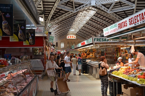
Open Market
People lived in Spain for thousands of years before the United States was discovered. Christopher Columbus lived in Spain. He left from Cadiz, Spain on three of his trips to America. He brought spices and salt back to Spain. Spain did not have refrigerators then. The spices were used to keep the food from spoiling and it make the food taste better after it went stale.
Buildings here are much older than buildings in the United States. We have visited churches that are over a thousand years old. They are made of stone. We are now in the city of Barcelona where there are sections of the city that are over two thousand years old.
Old Church
This week we are going to leave Spain and sail to the country of France.
Signing off,
Bob and Sara
Latitude: 41° 22.0’ N
Longitude: 2° 11.0’ E
PS: Quiz Question: What is different about our Longitude from all the other positions we have reported to you so far? What do you do differently when you plot our position now? What hemisphere does that have us in?
—————————————
The Atlantic Project/Quintessa Log #19, 8/11/2014
Gibraltar
Hi Crew,
Gibraltar is a fun country to visit. We spent two weeks here. Gibraltar is a British Territory, which means the people who live there are British citizens. English is the official language of Gibraltar. Do you know what Gibraltar is most famous for? Answer: The Rock of Gibraltar.
Gibraltar is one of the smallest countries in the world. The whole country is one tenth the size of Andover and over half of the country is covered by the giant rock that sticks up 1,400 feet. A rock that is so big there are 30 miles of tunnels inside it.

Rock of Gibraltar
How did the rock get here? Millions of years ago when the tectonic plates that form the continents came together the rock was broken out from the old seabed and pushed upward. When it stopped it was upside down. Even today it looks odd.
Quiz question: what is a tectonic plate?
We rode a cable car to the top of the rock and walked back down. It took us about five hours to walk down. The road took us through some of the tunnels. The military dug tunnels throughout the rock and created a fort. The openings in the rock look down on the water that surrounds Gibraltar to defend the country from attack.
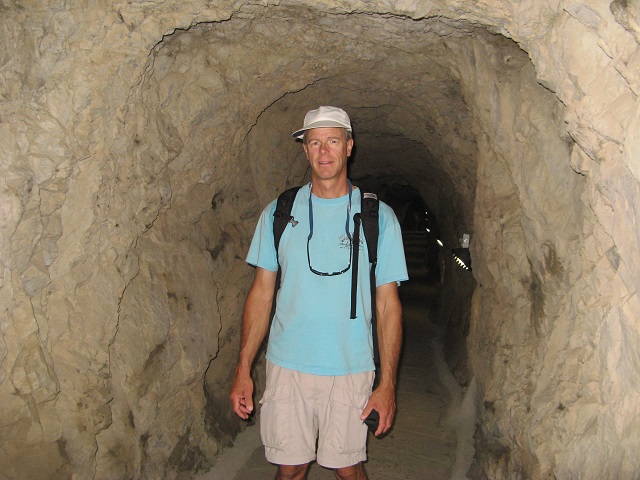
Bob in one of the tunnels
The rock is also where the Barbary apes live. Barbary apes are a type of monkey. About 300 apes live near the top of the rock. They stroll all around, and they go in and out of the visitor center. This is the only place in Europe where apes live in the open. They are not afraid of people. Sometimes they will climb on a person or sneak up and open their bags and backpacks to steal food. They are fed fruits and vegetables by the park rangers.
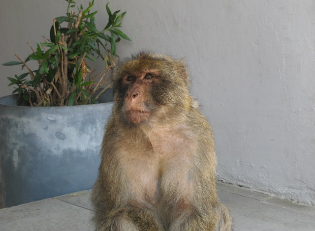
Barbary Ape
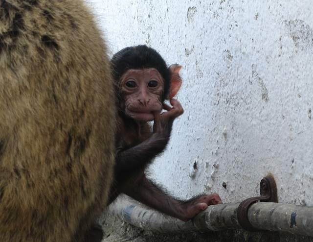
Baby Ape
Gibraltar is bordered on one side by Spain. Since people go back and forth to Spain all the time, most people in Gibraltar also speak Spanish. The other side of Gibraltar is water called the Straits of Gibraltar. It is the water that connects the Atlantic Ocean to the Mediterranean Sea. It also separates Europe from Africa. There is only nine miles between the two continents. We could see the country of Morocco, in Africa from Gibraltar.
Every boat must fly the flag of their home country on the back of the boat. We are flying an American flag. We have not met many Americans since we crossed the Atlantic Ocean. We keep a book on the boat that shows flags from all over the world. It tells what country each flag represents. Most of the boats we have seen are from France and Germany. We are keeping a list of countries that boats are from. It is fun to see how far some boats have sailed to be here. We have seen boats with flags from Russia, Japan, Norway, and Namibia, which is in the southern part of Africa.
Signing off:
Bob and Sara
s/v Quintessa
Latitude: 36° 08.0’ N
Longitude: 5° 21.3’ W
—————————————————-
The Atlantic Project/Quintessa Log #18, 7/9/2014
Lisbon
Hi Crew,
It is hard to believe that summer is over and you are now back to school in the 5th grade. We hope you had a great summer vacation. And, to the 4th grade classes who are joining us this year in the Atlantic Project adventure, welcome! We are looking forward to having you on board and to meeting all of you later in the fall.
We are now in Europe. The last time we wrote to you we were in Horta, one of the islands in the Azores. The Azores are a group of nine islands located out in the Atlantic Ocean. They are part of the country of Portugal. They are located about 1,000 miles away from the coast of Europe.
In Horta, the sidewalks and walls around the marina are covered with paintings. The paintings are done by the boaters who have sailed across the Atlantic. They are celebrating their success. People now think it is bad luck to not do a painting about your boat. So we did one! Bob designed and painted a picture about our boat, Quintessa. He put the names of the crew on it. He also included West Elementary as you are part of the crew too!
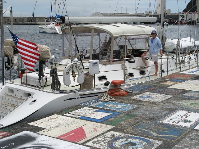
Sara by boat in Horta
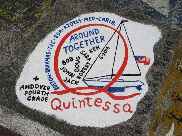
Quintessa logo painting on sidewalk
When we left Horta we sailed for six days and nights to reach Lisbon, Portugal. On the way a school of dolphins joined us. They swam along the sides of the boat. Dolphins are very smart and friendly. We called to them and asked them to jump out of the water. They did! We have a video of them swimming with us.
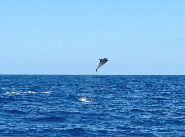
Dolphin jumping out of the water
Lisbon is the capital of Portugal. It is on the main part of Europe. People speak Portuguese here. It is a very old city. Parts of the city are so old that it has streets that are very narrow and twisty, from before there were cars. Today, only one small car can get through at a time. Another reason the streets were made so narrow is so the sun would not shine down between the buildings as much. Buildings block the sun and make the streets shady. In the summer the sun is very hot so people try to stay out of the sun. They also keep the shades down on windows to keep the sun out. Outdoor restaurants have awnings over the tables with misters built into them. Several times every minute a mist of water is sprayed over everyone sitting at the tables. It is not very much water. It does help cool you off.
Quiz question: why does a mist of water make you feel cooler?
Narrow streets in Lisbon
In the afternoon stores close for a few hours, then open again. They close because it is so hot. People take a “siesta” then. During siesta they have their big meal of the day and sometimes take a nap. Then they go back to work. The stores then stay open later in Portugal. Dinner is not until after 9:00 at night. It is cooler then and many people spend time outdoors. We see kids on the playgrounds very late in the evening along with people in the parks and walking their dogs.
Signing off,
Bob and Sara
s/v Quintessa
Latitude: 38° 40.5’ N
Longitude: 9° 19.0’ W
Click on Link below to view Dolphin Video (or copy and paste into your browser):
——————————————
Log #17 – June 18, 2014
Azores
Hi Crew,
Well, we made it across the Atlantic Ocean to the Azores. The Azores is part of the country of Portugal. It is about 800 miles out in the ocean from the main part of the country. That is like Hawaii being part of the United States and being a long way from the rest of the states. The language here is Portuguese. Some people also speak English. The money they use is the Euro which is used in all of the European countries.
Our trip from Bermuda to the Azores took 11 days. It was shorter than we expected because we had very strong winds. We went 1770 nautical miles in 11 days. How many miles did we average each day? What was our average speed in nautical miles per hour (knots)?
The Azores is made up of 9 islands. Some of them have tall volcanoes on them. The volcanoes are not active now. Even though there are a lot of islands, there are no sandy beaches. The shores are very rocky. Some parts of the islands have tall cliffs that drop off into the sea. They are very beautiful.
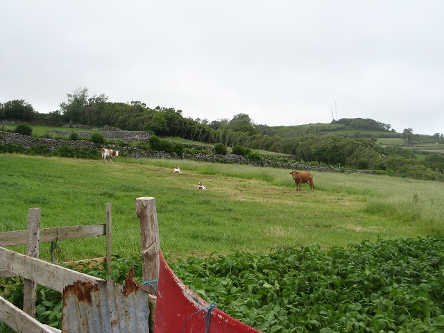
The islands have a lot of cows and green fields. Most of the fields have borders made of stone walls. The stone walls mark the edges of property and also keep the cows inside. They make cheese here and grow most of their fruits and vegetables. They grow lettuce, tomatoes, oranges, figs, grapes and pineapples. There is also a lot of fishing. People here eat a lot of fish.
 Pastures and crops in Flores
We are in the town of Horta, in the middle of the islands. There are about 300 sailboats here from around the world. Most are from France and Germany. Very few are from the United States. Many of these people sailed across the Atlantic Ocean like we did. We met one family that had rescued a man at sea whose boat had broken down. They put him on their boat and sailed him the rest of the way across the ocean to Horta. He was very lucky they found him.
 Harbor in Horta w/ sailboats
Boat repair and supplies are a major business here. Boaters stop here on their way across the ocean to buy more food and any repair parts they need for their boats. We had been at sea for almost two weeks when we got here so we did laundry here too. We do not have a washing machine on the boat.
We will enjoy seeing these islands for another week. Then we will sail on to Lisbon, Portugal which will take about 5 days. Look at the map and you will see the distance from the Azores to Lisbon is about 750 miles across the ocean. While you are on summer vacation we will be sailing the coasts of Portugal, Spain, Morocco, and France. You will see blogs on those areas when you get back to school in Sept.
Have a wonderful summer vacation. Do lots of reading. You can write us notes at the end of the summer to tell us what adventures you have had. Someone will bring the notes to us. We are always like to hear what you are doing.
You have been a great crew this year!! Thank you. We will see you again in the fall.
Bob and Sara
Latitude: 38° 32’N
Longitude: 28° 37’W
————————————————–
Log #16 – June 3, 2014
Azores Passage
Hi Crew,
Hello from the middle of the Atlantic Ocean. Today is a very exciting day. Today we are half way to the Azores from Bermuda. Do you remember what that means? Today we tossed the message in a bottle into the ocean. In it is the paper you all signed your names on. We also wrote a message to the person that finds the bottle. It says that you send them peace and good will and asks them to please contact your class at West Elementary to tell you who they are and where they found the bottle.
 Sara dropping bottle in the ocean
We put today’s date on the message so you will be able to find out how long it took to be found. Remember the bottle will travel in the current of the ocean. That is not fast and the bottle has a long way to travel before reaching land. We do not know what country it will land in. It may take two months or it may take two years to be found. That will be a surprise.
We left Bermuda last Wednesday. So far we have sailed the entire way and have not used the engine at all. The wind has been very strong so we are going faster than usual. Right now we are going almost 9 knots. The wind is from the southwest at 15-20 knots.
On our second day at sea we saw six dolphins. They swam along with the boat for a few minutes. They jumped into the air to show us their tricks! The next day we saw a whale. It was as long as the boat. We saw it blow water out or its blow hole as it was breathing. Do you remember how a fish breathes differently than a whale?
Tonight we will celebrate being half way to the Azores. We have a surprise for the crew. We are having whoopie pies for dessert. That is a real treat on a boat. We hope they like them.
Our current position:
Latitude: 35*18′
Longitude: 50*15′
Signing off,
Bob and Sara
———————————————
Log #15, 5/23/2014
Bermuda
Dear Crew:
We had so much fun spending time with you last week. Your questions were great. You are awesome crewmates! We are now back on the boat in Bermuda. There are a few projects we need to finish and we will be ready to start the next part of our journey. This time we will be sailing across the Atlantic Ocean from Bermuda to the Azores. Can you find that route on the world map?
Bermuda is the oldest colony of England in the world. That is like being one of the states in the United States. Bermuda has its own government and also is part of the English empire. It is like Massachusetts being its own state and also being part of the United States.
In 1609 Admiral Sir George Somers set sail with a fleet of nine ships from England to go to the new colony of Virginia, in what is now the United States. He was aboard the lead ship. There were 150 sailors, settlers, and a dog with him.
The fleet was caught in a severe storm on the way. The lead ship was separated from the rest of the ships. The sailors saw the reefs near Bermuda and were able to steer the ship toward the rocks.
The ship got wrecked on the reefs of Bermuda. All on board, including the dog, were able to get to shore safely. Over the next year, using resources from Bermuda and parts of the old ship, they built two new ships and sailed on to Virginia.
Later, during World War II, the United States built a navy base and the airport in Bermuda. Before that Bermuda had no cars. People rode horse and carriage, and on a public railway that stretched from one end of Bermuda to the other.
Bermuda is 21 square miles. It has a population of about 65,000.
- What is a square mile?
- How big is Andover?
- How many people live in Andover?
- How does Andover compare to Bermuda?
Fun facts: Bermuda is the 5th smallest country in the world.
It is 3rd highest in the world for population density.
Many people visit Bermuda on vacation. It is an important part of the economy. The island has rocky cliffs and beautiful beaches with soft pink sand and crystal clear water. There are a lot of beautiful hotels and resorts along the coasts of Bermuda.
 Resort with pink sand
The homes in Bermuda are spread all across the island and tend to be small by American standards. Because the island is small there is not a lot of room for big houses and roadways. Everything is scaled down; even the cars and trucks are smaller. The towns are very quaint having pastel painted homes, all with white roofs. The white roofs are very important in Bermuda. Water on the island is valuable so homes have special roofs that collect water and store it in large tanks in the ground called cisterns. Some homes collect additional water by capturing runoff in the yard with large cement areas that look like playgrounds.
 Water catch
Have you ever heard of Bermuda shorts? Men in Bermuda often wear them as part of their business suit. They can be very colorful. Bermuda shorts are always worn with knee socks and leather shoes. Most of the time men also wear a suit jacket and tie with them. Bermuda has a law that shorts cannot be any shorter than six inches above the knee.
 Going to work
Fruits and vegetables are grown on the island. There are farms that raise cows and chickens and produce milk and eggs. About 20 percent of Bermuda’s food needs are produced right here on the island. There is not a lot of open land for farming. Bermuda has become very clever locating fields in tight places. Bermuda has rich soil and good rainfall. It is able to supply a lot of its own food to help lower the cost of importing food. This is very different from the other islands we have visited where there is very little food production.
 Farm Land
There are tree frogs in Bermuda. They sing whenever the temperature is over 70 degrees. That is most of the time!
If the weather is good, we will leave Bermuda on Wednesday. We will send you some emails from the middle of the ocean. When we are half way to the Azores we will put your names that you wrote and a message in a bottle and put it into the ocean. Where do you think it will float to?
We should be in the Azores before you get out of school for the summer.
Bob and Sara
————————————————————-
Log #14, 4/21/2014
Turks and Caicos
Hi Crew,
Greetings from the Turks and Caicos Islands. This country is made up of 40 islands. Most of the islands are very small. They are located over 500 miles east of Florida. The islands are flat with only a few hills. Christopher Columbus, who discovered the United States in 1492, also landed his boat in the Turks and Caicos the same year. How long ago was that?
In the 1600s there were pirates in these islands. They were here for about 100 years. There are no pirates here now.
The color of the water here is aqua and very clear. The sand on the beaches is soft to walk on. The water around the islands is very shallow with a lot of coral reefs. Notice how easy it is to see the reefs in such clear water. Many people scuba dive and snorkel here to see the coral and the fish. We have done both.
 Clear water of Middle Caicos
Our favorite part of the Turks and Caicos is the Potcake dogs. Potcake dogs are found only in the Bahamas and the Turks and Caicos islands. Most of the dogs do not belong to anyone. They are strays. The name Potcake came from what people used to feed them. A very common food here is a mix of peas and rice. When it is cooked and reheated, it tends to leave some stuck to the bottom of the pot. People call that a Potcake. They feed it to the dogs. The dogs then were named Potcake dogs. That name is now official.
 Sara with Potcake Pups
The Potcake dogs have a similar body shape. Most are brown, but they can be all different colors. They weigh about 45-50 pounds. Most important is they are very smart and very sweet. They have no family so they need to find food on their own. They usually travel in a pack and stick together.
We have four Potcake dogs that live in the marina we are at. They have been living here for about two years. They take care of each other. Their names are Annie, Wiggles, Sox and Gramps. People who work at the marina give them food and water. We love them and feed them every day. They know us now. When they see us get off the boat they run to greet us. Bob has taught Wiggles and Annie to “sit” and “lie down” for treats. They are smart.
At the end of next week we are going to leave the Turks and Caicos and sail on to our next country. That country is Bermuda. To get to Bermuda we will sail northeast from here. It will take about one week without stopping. That means that we will sail all day and all night for a week. We have done this trip before and did not see any other boats the whole way. Two friends will be on the boat with us as crew.
We are looking forward to seeing you next month when we come back to Andover to visit!
Signing off,
Bob and Sara
———————————————————
Log #13, 4/4/2014
Bahamas School
Hi Crew,
School in the Bahamas is a lot like school in Andover. Students go to school from September until June. They have the summer off. The school day is from 9:00 to 3:00. They study the same subjects that you do. They have math, science, social studies, and reading.
We went to visit a school in a town called Black Point in the Bahamas. It is a small town in the Exuma Islands in the Bahamas. The island that Black Point is on is smaller than Andover. Only 300 people live on the island. There are cars on the island but most people drive golf carts because the island is so small. The food for the stores and the mail come to the island once a week on a boat.
There are nice sandy beaches around the island. The water is so clear that you can see the bottom even when the water is 20 feet deep. The water color is pale aqua and beautiful. The water temperature is 85 degrees.
The school is called an All Age School because the preschool, elementary school and middle school are all in one building. There are only 49 students in the whole school! Each teacher teaches three grades. Kindergarten and grades 1 and 2 share one classroom. Grades 3, 4 and 5 share one classroom, and the middle school shares one classroom. The playground has a basketball net and a trampoline.
 School at Black Point
There is no high school on the island. High school students go to school in the city of Nassau which is about 100 miles away. Most of them live with cousins or other families while they go to school. They only go home on school vacations.
All students in the Bahamas wear uniforms to school. The boys wear shorts or long pants with shirts and ties. The girls all wear skirts and blouses with neckties. Each town has their own colors for uniforms, like you do in your sports uniforms.
 Delivering books to school
You were wonderful donating books back in December. We took the books to the school at Black Point. The principal was so happy that she gave us both hugs. The students all started to choose books right away. A first grader was thrilled to find a book on puppies. Thank you to all of you for sharing your books with another school. They have no bookstores on the island. They have a tiny library at the school. Kids there do not have computers or computer games, so books are very important.
 Looking through the books
We are now in a new country! It is called the Turks and Caicos. The Turks and Caicos are made up of a group of islands just south and east of the Bahamas. Last week we sailed from the Exuma Islands in the Bahamas to the Turks and Caicos. We sailed about 250 miles to get here. Our speed was about 6 knots per hour. How many hours did the trip take?
We had very high winds and big waves for the entire trip. For the first two days and one night we sailed without stopping. That means we sailed all night long. The stars in the sky were awesome. There are no other lights around so the sky is very dark and the stars seem much brighter. We could see thousands of stars.
The second night we stopped near an island and put our anchor down so we could get a good night of sleep. The last day we made the final distance to the Turks and Caicos. We anchored the boat in a beautiful bay just as it was getting dark. We are very happy to be here.
Bob and Sara
Latitude: 21° 45.64N
Longitude: 72° 10.50W
——————————————————
Log #12, 3/14/2014
Bahamas Animals
Hi Crew,
We have left the United States and are now in The Bahamas. The Bahamas is a country made up of 700 islands. Most of the islands are very small. There are no people or houses on most of the islands. The weather here is hot even in the winter. There are alot of palm trees and banana trees. The water is very clear. You can see everything on the bottom even in deep water.
While we were sailing from Florida to the Bahamas Bob put out the fishing rod to see if we could catch a fish. Guess what! We caught a beautiful Dorado fish. It is also called mahi-mahi. It was blue, green and yellow and was 42 inches long. Bob reeled it in on the fishing pole and Sara caught it into a big net to pull it onto the boat. We took pictures of it. Bob then cleaned it. We had some for dinner and have alot in the freezer.
The seashells are beautiful. Every island has its own types of shells. We are collecting some for the boat. They are different sizes and colors. We sent you a postcard that will show you what some of them look like.
Last week we were at an island that has iguanas. They are about two feet long. When we got to the beach they walked out onto the sand to meet us. They look like small dinosaurs. This type of iguanas are no where else in the world. They are the largest native animal living on land in the Bahamas. They eat plants. They are protected by the government. It is illegal to harm them or to harass them.
 Iguana on the beach
Another island we went to has wild pigs. There are no people living on that island. It only has pigs and chickens. Have you ever seen a pig swim? The pigs on this island do swim. When people from the nearby boats go to the beach at the island the pigs come out to visit. They are looking for food. People bring them lettuce and carrots to eat. Most of the pigs are friendly so people will feed them. Sometimes the pigs will swim out to the boats to get food. There are adult pigs that are huge. There are also alot of young pigs that are small. The pigs do not chase people on the beach. They have learned that if they chase people they will not be fed. They are smart pigs!
 Bob feeding wild pigs
Now we are at another island called Compass Cay. There are no stores or cars here. There are four houses. Just a few people live here. They also have sharks that live here. This type is called nurse sharks. These sharks are about 6 to 8 feet long. They can be up to 13 feet long and weigh 700 pounds. They like to swim in shallow water. During the day they rest. At night they feed and eat fish, shrimp, and lobsters. Mother nurse sharks have 20-30 babies at once which are called pups. The pups look like tiny adult sharks.
 Nurse Shark
Some people swim with the sharks here. Bob swam with them but Sara would not! She was too scared. These sharks live here all the time. The people who sail here have given all of the sharks names. Some of their names are Chunky, Mutt, Hook, Woody, Squirt, Scar, Herman, and Jack. What name would you give to one of the sharks?
Logging off,
Bob and Sara
Latitude: 24° 15.5 N
Longitude: 076° 30.5 W